 https://greenmarked.it/wp-content/uploads/2024/03/nareeta-martin-FoG7PKNYjpM-unsplash-scaled.jpg
1707
2560
Barbara Centis
https://greenmarked.it/wp-content/uploads/2022/01/LOGO-GREENMARKED-SITO-600x600.png
Barbara Centis2024-03-21 21:10:062024-03-22 23:07:21Waste Management: State of the Art and Future Emergencies
https://greenmarked.it/wp-content/uploads/2024/03/nareeta-martin-FoG7PKNYjpM-unsplash-scaled.jpg
1707
2560
Barbara Centis
https://greenmarked.it/wp-content/uploads/2022/01/LOGO-GREENMARKED-SITO-600x600.png
Barbara Centis2024-03-21 21:10:062024-03-22 23:07:21Waste Management: State of the Art and Future EmergenciesJune 13, 2023

“… and that is how the Dona lost her Omo”
To most of you readers, these words may seem nonsensical, decontextualized, and meaningless. Unfortunately, this is not the ending of a fairy-tale love story, a poorly written adventure novel, or the new recording of a budding singer-songwriter. The story is the real and tangible one of a millennial married couple who separate under the pressure of a heavy, continuous, unexpected rain.
The two rock pinnacles that soar – or rather, towered – on Monte Plische (precisely, the Omo and the Dona), on the border between Veneto and Trentino, south of Rovereto in the municipality of Recoaro Terme (Vicenza, Italy), are for us locals a kind of symbol, an emblem considered immutable, a fixed star of the skyline of our mountains.
Yet, like everything in nature, unchanging it is not. So much so that today, at first light, after a week of thunderstorms and heavy rain in the area, the entire valley woke up without part of this symbol.
But how is this possible? The two pinnacles have always been there since living memory!
And if on the one hand, with a veiled – and not even too much – healthy parochialism, I am pleased to be able to introduce this technical-hydrogeological discussion starting from a fact of absolute territorial marginality, on the other hand, however, I perceive a sense of helplessness in the face of nature’s magnificence, which this time affects me directly.

Fig. 1: Mount Plische, Carega Group. Middle: “La Dona,” isolated from “L’Omo.” (Author. Recoaro Terme, Italy. June 11, 2023)
Landslides, rockfalls, avalanches and … forests! Or, anyway: trees, plants, and shrubs are the protagonists of this story. And the narrator is water.
In economic terms, the situation in Veneto looks promising for the current year. It was a few weeks ago that the Governor announced the allocation of more than 25 million euros to combat hydrogeological instability in the regional territory. Funds that will be allocated primarily to works of embankment, riverbed arrangement, and cleaning, in almost all the provinces of Veneto [1].
And it is also true that important works in the regional territory have already been carried out over the years. Following the flood of 2010, which hit the provinces of Vicenza, Verona and Padua hard [2], the Region endowed itself with a Plan of absolute depth – the so-called “Piano d’Alpaos”, named after the professor at the University of Padua who oversaw its drafting – worth over 3 billion euros in investments against hydrogeological risk.
To date, more than 40% of the Plan is reported to have been implemented, with investments put in place in excess of 1.5 billion euros, including [3]:
⦁ Completion of Trissino di Monte basin on the Agno-Guà river (22.7 million the value of the intervention) 40% of Trissino di Valle basin (20 million intervention);
⦁ Near completion San Lorenzo basin in the Verona municipalities of Soave and San Bonifacio (5.9 million euro work);
⦁ 80% of the one on the Bacchiglione River upstream of Viale Diaz in Vicenza’s capital city (18.75 million euro intervention);
⦁ 70% of the first functional lot of the one on the Muson stream, in the municipalities of Fonte and Riese Pio X in the Treviso area (€18.6 million value).
For Trentino, the situation is also positive, with 7 million allocated by the Government to the year 2023 for defence works identified by the province in coordination with the territories [4].
In total, interventions in the provincial territory for about 13.5 million euros are approved for the current year, related to the state of emergency in October 2018 [5].
In short, there seems to be no shortage of initiatives and funding pe these territories. Yet with every event that occurs in the territory, fronts of criticism open up (often rightly so). Between those who cry of inefficiency, incompetence, and tardy response and those who justify and praise the work of those in charge, the fact remains that for the entire peninsula, almost 94% of municipalities are at risk of landslides, with the Province of Trento reaching even 100% of municipalities, for a population residing in landslide hazard areas of more than 22% of the total.
Numbers, these, however, compare with a reality on the ground that can help and support risk prevention itself. Because, while it is true that extreme weather events are a product of nature itself (anthropogenic climate change excluded), it is also from nature itself that humans can benefit.
And in this, the forests come to the rescue. Indeed, afforestation interventions in alpine areas, which have been active since the 1960s, have proven effective and have shown their capacity in terms of protection and support or replacement of traditional technical measures against hydrogeological hazards. However, necessary assessments regarding soil type, elevation, planting techniques, exposure, and socio-economic implications are still to be considered. Moreover, maintaining the effectiveness of such biological protective structures is only ensured by active forest management that can enable forest resilience and persistence.
In short, technical and applicative knowledge is necessary for proper and effective land use planning, including forestry, but it can supplant and help against the advance of risk.
Because in the end, as a colleague of mine, who is not so much a forester but so much a human being said about the recent floods in Emilia-Romagna: “A river will always act as a river”.
That is to say, it is useless to try to change what nature dictates. However, it is up to us to plan actions that can put us in a safe condition, making the best use – when possible – of nature itself.
This article is part of the project “PILLOLE D’ACQUA PIANA: seminari itineranti, blog e podcast per una gestione sostenibile delle risorse idriche in Piana Rotaliana” carried out by ECONTROVERTIA APS and supported by Fondazione Caritro (Prot. no. U445.2023/SG.386 of April 23, 2023).
![]()
![]()
Related articles:
https://greenmarked.it/wp-content/uploads/2024/03/nareeta-martin-FoG7PKNYjpM-unsplash-scaled.jpg
1707
2560
Barbara Centis
https://greenmarked.it/wp-content/uploads/2022/01/LOGO-GREENMARKED-SITO-600x600.png
Barbara Centis2024-03-21 21:10:062024-03-22 23:07:21Waste Management: State of the Art and Future Emergencies https://greenmarked.it/wp-content/uploads/2024/01/IMG_5727-scaled.jpg
1920
2560
Matteo Gecchelin
https://greenmarked.it/wp-content/uploads/2022/01/LOGO-GREENMARKED-SITO-600x600.png
Matteo Gecchelin2024-01-22 22:16:182024-01-22 23:24:18A Battle in the Alps: A Story of Climate and Men
https://greenmarked.it/wp-content/uploads/2024/01/IMG_5727-scaled.jpg
1920
2560
Matteo Gecchelin
https://greenmarked.it/wp-content/uploads/2022/01/LOGO-GREENMARKED-SITO-600x600.png
Matteo Gecchelin2024-01-22 22:16:182024-01-22 23:24:18A Battle in the Alps: A Story of Climate and Men https://greenmarked.it/wp-content/uploads/2024/01/agriculture-1359862_1280.jpg
734
1280
Barbara Centis
https://greenmarked.it/wp-content/uploads/2022/01/LOGO-GREENMARKED-SITO-600x600.png
Barbara Centis2024-01-11 22:56:552024-01-11 23:48:14The Time of Glyphosate
https://greenmarked.it/wp-content/uploads/2024/01/agriculture-1359862_1280.jpg
734
1280
Barbara Centis
https://greenmarked.it/wp-content/uploads/2022/01/LOGO-GREENMARKED-SITO-600x600.png
Barbara Centis2024-01-11 22:56:552024-01-11 23:48:14The Time of Glyphosate https://greenmarked.it/wp-content/uploads/2023/12/gambero_rosso.jpg
1277
1920
Michele Claus
https://greenmarked.it/wp-content/uploads/2022/01/LOGO-GREENMARKED-SITO-600x600.png
Michele Claus2023-12-05 19:42:002023-12-06 12:02:18The Alien Crayfish
https://greenmarked.it/wp-content/uploads/2023/12/gambero_rosso.jpg
1277
1920
Michele Claus
https://greenmarked.it/wp-content/uploads/2022/01/LOGO-GREENMARKED-SITO-600x600.png
Michele Claus2023-12-05 19:42:002023-12-06 12:02:18The Alien Crayfish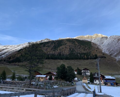 https://greenmarked.it/wp-content/uploads/2023/11/IMG_5742-scaled.jpg
1920
2560
Matteo Gecchelin
https://greenmarked.it/wp-content/uploads/2022/01/LOGO-GREENMARKED-SITO-600x600.png
Matteo Gecchelin2023-11-30 19:45:442024-05-16 10:22:53Enhancing Alpine Landscapes
https://greenmarked.it/wp-content/uploads/2023/11/IMG_5742-scaled.jpg
1920
2560
Matteo Gecchelin
https://greenmarked.it/wp-content/uploads/2022/01/LOGO-GREENMARKED-SITO-600x600.png
Matteo Gecchelin2023-11-30 19:45:442024-05-16 10:22:53Enhancing Alpine Landscapes https://greenmarked.it/wp-content/uploads/2023/11/cityscape-2747226_1280_v1.png
1280
1239
Barbara Centis
https://greenmarked.it/wp-content/uploads/2022/01/LOGO-GREENMARKED-SITO-600x600.png
Barbara Centis2023-11-13 11:41:442023-11-12 14:02:09Losing Soil, Losing Opportunities. A Threat for Trentino
https://greenmarked.it/wp-content/uploads/2023/11/cityscape-2747226_1280_v1.png
1280
1239
Barbara Centis
https://greenmarked.it/wp-content/uploads/2022/01/LOGO-GREENMARKED-SITO-600x600.png
Barbara Centis2023-11-13 11:41:442023-11-12 14:02:09Losing Soil, Losing Opportunities. A Threat for Trentino https://greenmarked.it/wp-content/uploads/2023/08/hail-123042-scaled.jpg
1920
2560
Barbara Centis
https://greenmarked.it/wp-content/uploads/2022/01/LOGO-GREENMARKED-SITO-600x600.png
Barbara Centis2023-08-19 18:46:222024-05-16 10:20:04The Summer of Hail Storms in Northeastern Italy
https://greenmarked.it/wp-content/uploads/2023/08/hail-123042-scaled.jpg
1920
2560
Barbara Centis
https://greenmarked.it/wp-content/uploads/2022/01/LOGO-GREENMARKED-SITO-600x600.png
Barbara Centis2023-08-19 18:46:222024-05-16 10:20:04The Summer of Hail Storms in Northeastern Italy https://greenmarked.it/wp-content/uploads/2023/07/Schio_LST_3D_02.png
986
1916
Matteo Gecchelin
https://greenmarked.it/wp-content/uploads/2022/01/LOGO-GREENMARKED-SITO-600x600.png
Matteo Gecchelin2023-07-28 16:55:162024-05-16 10:20:48What time is it? It’s summer heatwaves time
https://greenmarked.it/wp-content/uploads/2023/07/Schio_LST_3D_02.png
986
1916
Matteo Gecchelin
https://greenmarked.it/wp-content/uploads/2022/01/LOGO-GREENMARKED-SITO-600x600.png
Matteo Gecchelin2023-07-28 16:55:162024-05-16 10:20:48What time is it? It’s summer heatwaves time https://greenmarked.it/wp-content/uploads/2023/07/lago-water-reservoir-bubal-4373406.jpg
1280
1920
Barbara Centis
https://greenmarked.it/wp-content/uploads/2022/01/LOGO-GREENMARKED-SITO-600x600.png
Barbara Centis2023-07-17 09:12:322024-05-16 10:19:19Water Emergency is the New Normal in Trentino
https://greenmarked.it/wp-content/uploads/2023/07/lago-water-reservoir-bubal-4373406.jpg
1280
1920
Barbara Centis
https://greenmarked.it/wp-content/uploads/2022/01/LOGO-GREENMARKED-SITO-600x600.png
Barbara Centis2023-07-17 09:12:322024-05-16 10:19:19Water Emergency is the New Normal in TrentinoReferences:
[1] Regione del Veneto. (11.02.2023). OLTRE 25 MILIONI DI EURO PER CONTRASTARE IL DISSESTO IDROGEOLOGICO DEL VENETO. ZAIA: “12 NUOVE OPERE PER LA SICUREZZA DEL TERRITORIO” [Online; dated 10.06.2023]. https://www.regione.veneto.it/article-detail?articleId=13731700
[2] Dipartimento della Protezione Civile. (n.d.). Alluvione in Veneto [Online; dated 10.06.2023]. https://emergenze.protezionecivile.gov.it/it/meteo-idro/alluvione-veneto-2010/
[3] Regione del Veneto. (26.01.2022). DISSESTO IDROGEOLOGICO. BOTTACIN: “E’ UNA ASSOLUTA PRIORITA’ PER LA REGIONE. NEGLI ULTIMI DUE ANNI AVVIATI OLTRE 2000 CANTIERI PER 700 MILIONI DI EURO A CUI SI AGGIUNGONO I 3 MILIARDI DEL PIANO D’ALPAOS” [Online; dated 10.06.2023]. https://www.regione.veneto.it/article-detail?articleId=13439022
[4] ilTrentino. (16.02.2023). Dissesto idrogeologico, 7 milioni dallo Stato. Fugatti: “Priorità definite con i territori” [Online; dated 10.06.2023]. https://www.ufficiostampa.provincia.tn.it/Comunicati/Dissesto-idrogeologico-7-milioni-dallo-Stato.-Fugatti-Priorita-definite-con-i-territori
[5] Provincia Autonoma di Trento. (n.d.). Misure per la gestione del rischio di alluvione e la riduzione del rischio idrogeologico – interventi in essere [Online; dated 10.06.2023]. https://www.provincia.tn.it/Argomenti/Focus/PNRR-Piano-Nazionale-di-Ripresa-e-Resilienza/Misure-per-la-gestione-del-rischio-di-alluvione-e-la-riduzione-del-rischio-idrogeologico-interventi-in-essere
Cover- and preview image: Travignolo stream with the presence of trees crashed by storm Vaia in the riverbed. Photo by Author (Tonadico, Trento, Italy. August 13, 2020).

